27 November
at 22:20 pm
Article explanations clearly the pictures of volcanoes


27 November
at 20:20 pm
Daily update of the volcano
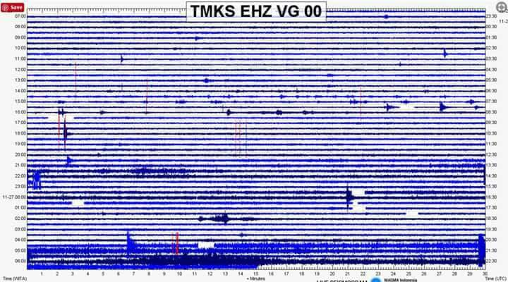
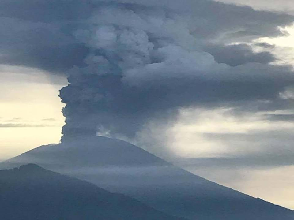
Activity in the mountains continued to rise last night until this morning. He did a good light show last night from the live camera at the Rendang Observation Post, with eruptions of lava in the crater reflecting on ash and steam. The crater continues to fill with lava, and PVMBG expects it to sink to the sides of the crater when full. The fuzzy lines at the bottom of the seismograph indicate continuous shifts in the movement of the magma inside. At 6:00 am this morning, PVMBG raised the alert to Level IV, but ONLY to areas within 10 km of the crater (see below). A full copy with the translation of the versions of yesterday and this morning will be uploaded to the files of the group shortly. - Cold lahars reports (mud / ash / water flows started arriving just before 07:30 this morning from the higher altitudes on the south side of the volcano. - Ashes drift east and southeast and should continue this pattern. I enclose the most recent BKMG report. - The VONA stays red. DPS was closed on all flights this morning at 07:00.
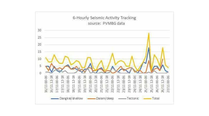
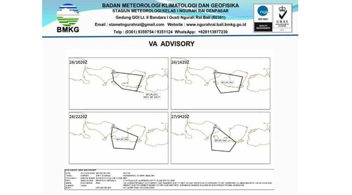
The airport remains closed. Reported on Monday, November 27, 2017 at 6:00 am Press Release of Mount Agung status increase from level 3 (alert) to level 4 (attention) by Ir. GEDE SUANTIKA, M.Sc as Chief of Mitigation Affairs from the observation of the volcano says that the eruption rate of Mount Agung has now gone from Phreatic to Magmatic since the fires were first observed at the peak on November 25, 2017 at 00.00 wita, until today the Magmatic eruption is accompanied by a continuous column of thick ash reaching the maximum height of 2000 to 3400 meters from the summit, in addition to the eruption of a continuous burst of ash accompanied by the sound of a faint bell ringing up to a distance of 12 KM from the top of the GA, which denotes the potential for a much larger eruption class LIFE 5, perhaps Therefore, the status of Gunung Agung changes from level 3 (standby) to level 4 (awas ) from 27 November 2017 pkl 06.00 wita."
27 November
at 18:00 pm
About Agung volcano
Source https://en.m.wikipedia.org
What kind of volcano Agung is ? A stratovolcano, also known as a composite volcano,[1] is a conical volcano built up by many layers (strata) of hardened lava, tephra, pumice, and volcanic ash. Unlike shield volcanoes, stratovolcanoes are characterized by a steep profile and periodic explosive eruptions and effusive eruptions, although some have collapsed craters called calderas. The lava flowing from stratovolcanoes typically cools and hardens before spreading far due to high viscosity. The magma forming this lava is often felsic, having high-to-intermediate levels of silica (as in rhyolite, dacite, or andesite), with lesser amounts of less-viscous mafic magma. Extensive felsic lava flows are uncommon but have traveled as far as 15 km (9.3 mi).
Stratovolcanoes are sometimes called "composite volcanoes" because of their composite layered structure built up from sequential outpourings of eruptive materials. They are among the most common types of volcanoes, in contrast to the less common shield volcanoes. Two famous stratovolcanoes are Krakatoa, best known for its catastrophic eruption in 1883 and Vesuvius, famous for its destruction of the towns Pompeii and Herculaneum in 79 CE. Both eruptions claimed thousands of lives. In modern times, Mount Saint Helens and Mount Pinatubo have erupted catastrophically.
In the relation to Indonesia is located along Sumatera Java and lesser islands that is Bali, Lombok, Sumbawa
27 November
at 17:25 pm
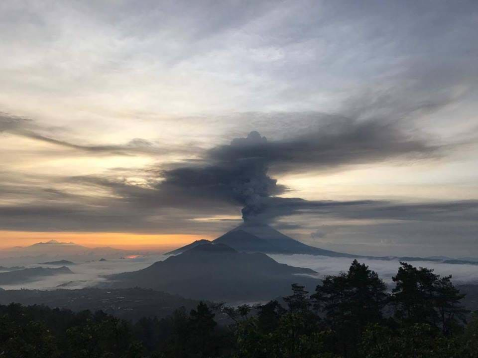
View from top of Batur last night

27 November
at 14:00 pm
Volcanic ash. Lahars, flow of ashes and water and rocks... This is the most dangerous phenomena for humans


27 November
at 11:25 am
Cold lava flows, "lahar" mix ash & rain, slow down to concrete thickness burying everything. Activities restricted 8-10 km from the top of crater & around the river that originated from Mount Agung.
Info and video by Gipsy Ayu
27 November
at 08:00 am
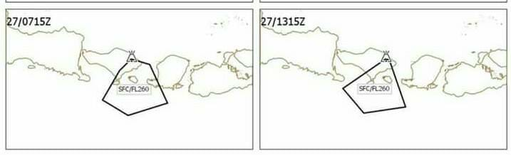
The last forecast about the wind and so the way of plume and ashes from Gunung Agung. South Bali is on the way (Sanur, Bukit, airport, Kuta, Denpasar and probably Seminyak, Canggu...)
All flights at the airport are deleted or canceled. Bring your masks with you and be safe.
27 November
at 0:20 am
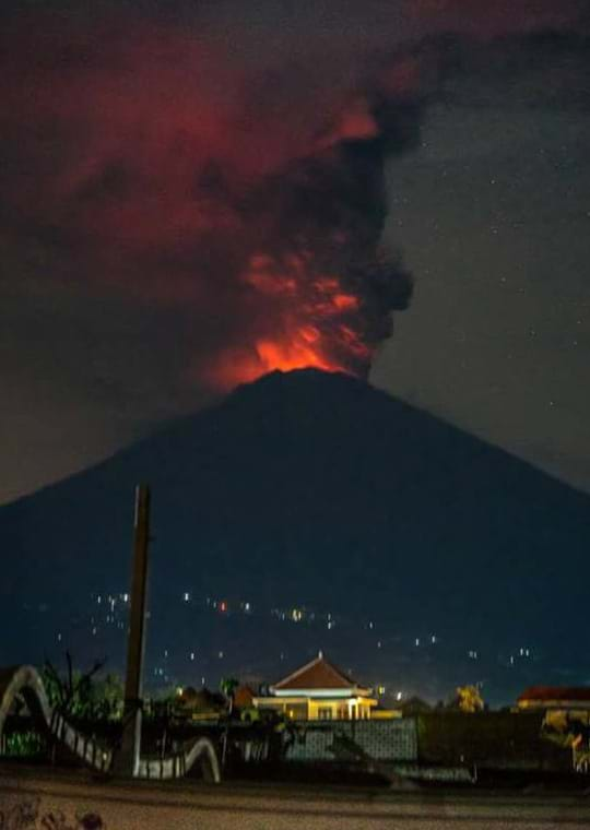
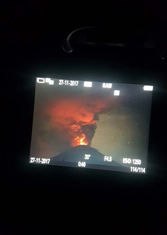
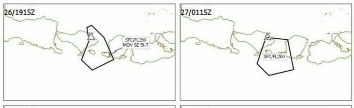
The last information (27/11/17. 00.20) The authorities inform that the last eruption was a magmatic eruption without explosion ( effusive eruption). It's important because it means the magma is already inside the crater ready to go out. From this fact, 2 options are possible: The lava goes out as a "river".
The lava goes out by the explosion and with all the risks about it. All depends on the pressure inside, from very deep inside the crater Bali airport still open with mostly all flights from Australia canceled, Lombock airport is closed. The wind still on a good way even for the next 48h hours, the previsions are less optimistic. Photos credit: Nicolas Gaultier Long exposition photo (you cannot see the red reflexion of the flames of lava only by eyes)