5 January
Daily volcano update
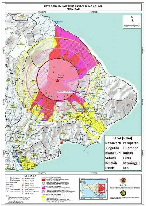
The dangerous area of Mount Agung is lowered from a radius of 8-10 km to 6 km (Just before the Besakih temple openning for tourist few day agos)from the peak of the crater by PVMBG. Status remains the same CAUTION Level4 (that means risk of eruption anytime). The villages located and the number of residents within the 6 km radius still to be displaced are still identified and still needs help.
Ministry of Energy and Mineral Resources, Republic of Indonesia
Press Statement
Number: 002.Pers/04/SJI/2018
Date: 04 January 2018
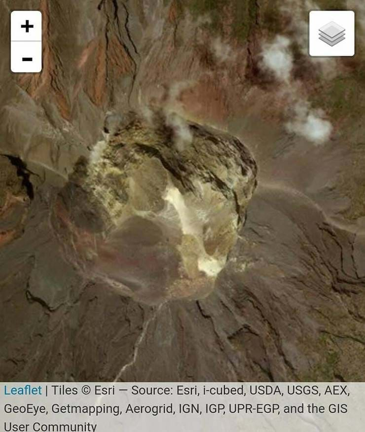
The Center for Volcanology and Geological Hazard Mitigation (PVMBG), Geological Agency of the Ministry of Energy and Mineral Resources (ESDM) establishes the status of Gunung Agung, Karang Asem, Bali is still "CAUTION", however PVMBG lowers the safe radius for activity to 6 kilometers from the previous 8 to 10 kilometers. Gunung Agung is currently in an eruption phase with relatively high volcanic activity and fluctuations. Based on the analysis of visual and instrumental data (seismic, deformation and geochemistry), Gunung Agung is still in the eruption phase, volcanic activity is still relatively high and fluctuating. Material eruption in the form of lava fills the crater, blowing/ash eruptions, and rocks are burst around the crater.
The volume of lava inside the crater is about 20 million cubic meters or about 1/3 of the crater volume (60 million cubic meters). The current dome growth rate is low so to fill the volume of the crater in a short time has a small likelihood.
The status of seismic activity in Gunung Agung until yesterday, Wednesday (3/1) at 18:00 WITA shows the amount of seismicity with high and low frequency contents to date still being recorded indicating the existence of pressure and magma flow from depth to the surface. However, current earthquake energy has not shown a significant upward trend. Deformation data in recent days also showed a stagnant trend indicating no significant increase in pressure sources. Recent geochemical data indicate the presence of SO2 magmatic gas with a flux of about 100-300 tons / day.
The current estimates potential hazard is the incandescent rock, sand, gravel, and heavy ash as well as the rain lahar [ash-mud flows, Ed]. The dangers of stones, sand, gravel, and dense ash are estimated to strike an area within a radius of 6 km from the crater. The danger of rain lahars following the stream courses which originate from Gunung Agung will depend on the flow of water and the volume of eruption material. With the scale of eruption at this time (intermittent), then the potential danger of Hot Clouds [pyroclastic flows, ed] is still relatively small because in addition to the slow growth of lava filling the crater, pyroclastic flows also require the development of considerable pressure under the lava dome to break it, and the development of pressure to date has not shown a significant pattern of increase.

Recommendation:
1. CAUTION status with a hazard area with previous radius of 8 km from Crater and sectoral expansion 10 Km, becomes 6 Km from peak. Status BEWARE [Level IV, Ed] is still maintained, considering that Mount Agung is still in the phase of eruption and impact on settlements.
2. The condition of Mount Agung is very dynamic then in relation to the continued CAUTION status each party is encouraged to maintain preparedness so that in case of rapid changes can be anticipated and responded to quickly.
