2 December
Daily volcano update
The Center for Volcanology and Geological Hazard Mitigation (PVMBG) plans to fly "drones" or unmanned aircraft to the summit of Mount Agung.
Drone flight was re-done to determine the condition of the last crater after the eruption a few days ago. "Hopefully next week the drones can be flown to the top. Given the current drone condition is still in the process of repair that previously successfully took the gas samples above the crater of Mount Agung, "said Head of Mitigation Division of Volcano Monitoring Eastern Region PVMBG Devy Kamil Syahbana at Post Monitor Village Rendang, Saturday (2/12) . Devy Syahbana added, this drone flight will be focused in taking data all that is on Mount Agung, be it visual data, smoke samples to know the gas content. "Although in the mission of flying the drones later only get visual data, it will be very meaningful to us. Therefore we can use as supporting data, "he said. Also read: Gunung Agung Disaster Refugees, A Number of SOEs Start Preparing Long Term Assistance He said, until now seismograph tool still record the occurrence of shallow volcanic earthquake and volcanic deep, low frequency and continuous tremors. With the still existence of the earthquake, shows there is still pressure in the belly of Mount Agung. Gunung Agung is still a critical phase. "This is what we need to anticipate what efforts should be done," he said. Furthermore, he said, on Friday (1/12) night also recorded an earthquake with 3.5 SR shock that must be wary of this, because there is still kaitannnya with the activity of Mount Agung. While from satellite monitoring, the estimated number of lava in the crater of Mount Agung one third crater with a diameter of 900 meters and depth of 200 meters is filled with volcanic lava material. "If converted the amount is nearly twenty million cubic meters of lava in the crater of a total volume of 60 million cubic meters," said Devy.
Eka Parananda / AMLAPURA, BALIPOST.com
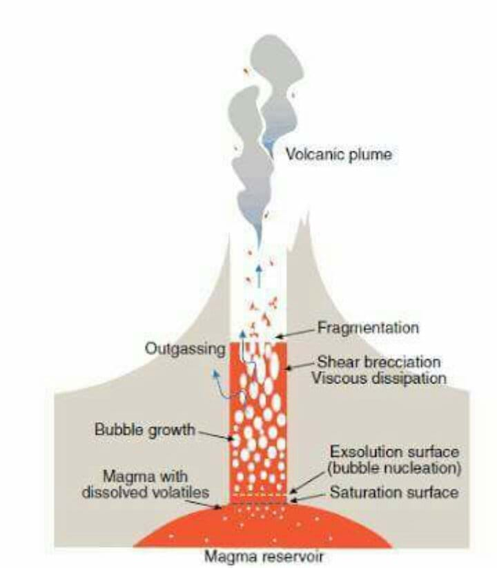
Few explanations to understand a stratovolcano as Gunung Agung
special thanks to Alain Delaplace Bali Francophone

Ministry of Energy and Mineral Resources Geological Agency Center for Volcanology and Geological Hazard Mitigation
The following update is based on multiple volcano monitoring parameters:
- A. Analysis of monitoring data
Visual observations
- After experiencing a swarm (series) of volcanic earthquakes during September and October 2017, on November 21, 2017 on at 17:05 WITA an eruption began at Mount Agung, Bali (elevation 3031 m or 9944 ft.). This eruption produced volcanic ash and gas that rose to heights of 700 m (2300 ft.) above the summit (12,000 ft. above sea level (ASL). Based on observations from the CVGHM Observatory Post stations, over the following week, the height of ash columns increased as follows: 25 November, 2017, 17:20, 1500 m above the summit (15,000 ft. ASL); 26 and 27 November 2017, 3000 m (20,000 ft. ASL), 28 November 2017, 4000 m (23,000 ft. ASL). Higher maximum altitudes (ASL) of the plumes were reported at times by the Darwin Volcanic Ash Advisory Center because they take into account clouds that contain ash that have drifted downwind from the volcano. CVGHMs ground-based observations estimate the ash cloud height by only measuring the vertically driven plume that contains ash (before the ash is dispersed). Then on 29 November 2017, the ash column height decreased to 2000 m above the summit (16,000 ft. ASL). These ash columns were gray in color and produced ash-fall in downwind areas. Since 30 November 2017 and continuing until today, the observed the column has been white in color and has had a maximum height of 2000 m above the summit (16,000 ft. ASL).
- Since the eruption began and continuing until today, red glow has been observed coming from the summit crater of Mount Agung. We attribute the red glow to the presence of high temperature lava in the crater. The red glow from the lava in the crater shines on the rising column of ash and steam and gives the lower part of the ash column a red color. Lahars have taken place since the ash eruptions began on 21 November. They have flowed down from the summit along rivers in in the southern sector of the volcano, including Tukad Yehsa, Tukad Sabuh and Tukad Beliaung as well as in the northern sector including Tukad Bara. These lahars have not resulted in fatalities. However, lahars have impacted houses, roads and agricultural areas.
Seismic
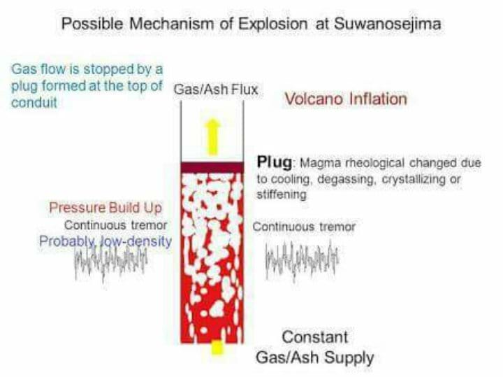
- High-frequency volcanic earthquakes continue at Mount Agung, and include both shallow (and proximal) and distal types, although the occurrence rate has decreased compared to September- October 2017. The decrease in number of volcanic earthquakes is attributed to the fact that a more open pathway for magma to rise to the surface is now present. However, high-frequency earthquakes continue to occur and show that the volcano is very active and capable of pressurization to cause the ongoing eruptions. Continuous seismic tremor has taken place from 28 November 2017 through today (December 1 , 2017). Amplitude of the tremor has ranged from just above the background levels of the CVGHM seismic network to over-scale (i.e., exceeding the recording limits of the instruments used). The tremor is a result of the ongoing gas and ash eruptions through the summit crater.
- Low frequency earthquakes have also taken place and are attributed to movement of magmatic fluids as they rise to and are erupted at the surface.
Deformation
- Data from the GPS network did not show significant changes prior to the eruptions on November 21 and Nov. 25. In August and September, there had been several centimeters of inflation that likely was caused by accumulation of magma beneath the volcano. In addition, tiltmeter data showed inflation before the eruption began and deflation during the eruption, as is common at other volcanoes.
Geochemistry
- Laboratory analysis of ash from the initial eruption of 21 November 2017 show the existence of juvenile fragments (i.e., from new magma) as well as fragments of old lava from deposits below the vent, such as those formed during the 1963 eruption and before. Consequently, we conclude that the initial eruption on 21 November 2017 was phreatomagmatic (i.e., that it took place when the new 2017 magma interacted with groundwater below the crater.
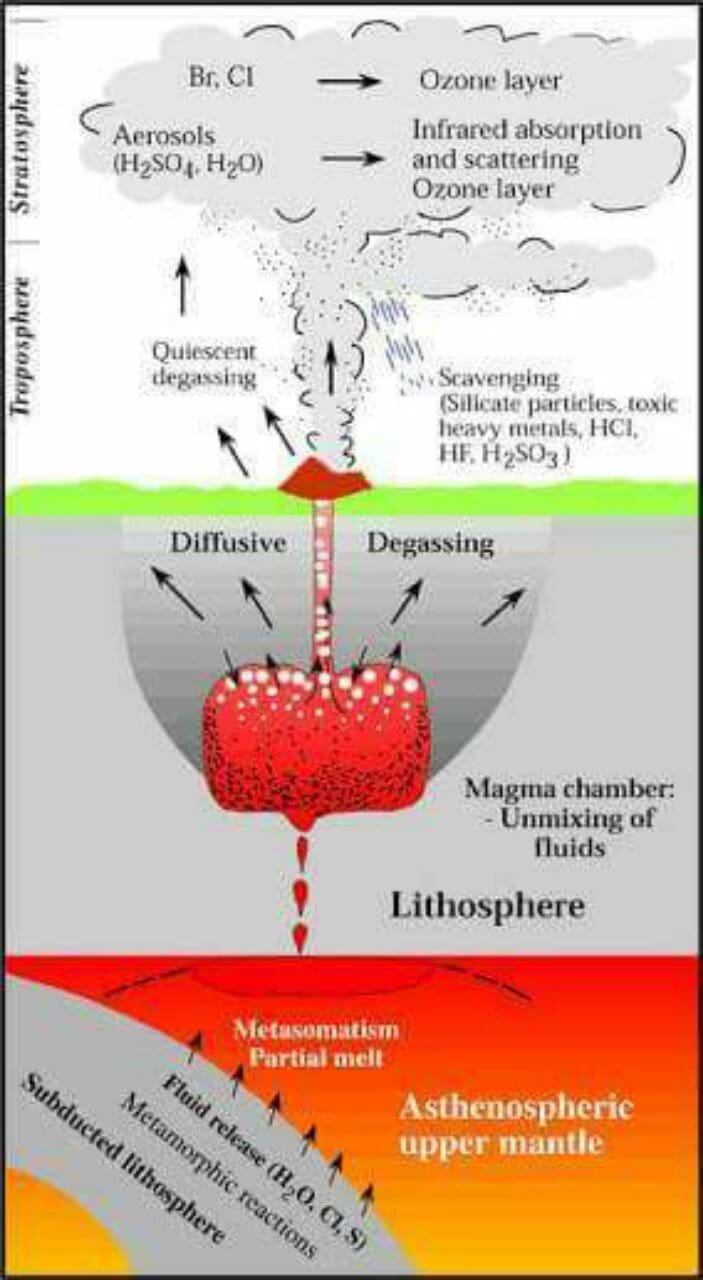
- Before the eruption of 21 November 2017, CO2 gas was measured at a high concentrations by MultiGAS equipment flown using a drone. However, very little SO2 gas was detected until after the November 21, 2017 eruption. Measurements of SO2 gas were highest during 26-27 November 2017; the concentration of SO2 has decreased somewhat since that time. These data are consistent with magma rising from great depth during the extended period of seismic unrest and reaching the summit crater of Mount Agung by the time of the 21 November eruption.
Satellie remote sensing
- Satellite data also indicate that eruption of lava is ongoing within the summit crater. These data have recorded high temperatures consistent with new lava within the crater on 27, 28 and 29 November 2017. The volume of lava in the crater is currently about 20 million cubic meters, equivalent to about a third of the total crater volume.
- Satellite data have recorded a hot area within the crater on 27, 28 and 29 November 2017 with temperature ranges estimated at about 300 degrees Celsius. Because of technical considerations, these are regarded as minimum temperatures. The lava in the crater is much hotter, likely in the range 900-1200 degrees Celsius, based on comparison to lava from the 1963 eruption of Mount Agung.
- B. Conclusions
- Based on multi-parameter data analysis and as of this date (1 December 2017 WITS) we conclude that volcanic activity at Mount Agung is still high. This is an ongoing eruption. Consequently, the Alert Level remains at Level IV (Awas). Communities around Mount Agung as well as climbers / visitors / tourists are advised to not climb or conduct any activity in the Hazard Zone, namely in the area of the crater of Mount Agung and at a radius of 10 km in sectors to the the north and northeast and southeast, south and southwest of the crater. An 8 km radius from the summit also applies to all other areas. For details of hazard areas please refer to the map at: Provide link to hazard map with sectors shown here!_. This is a dynamic situation and the nature and extent of the Hazard Zone may be changed at any time. It is still considered safe for traveling in Bali outside of the Hazard Zone as described above..
Daily volcano update
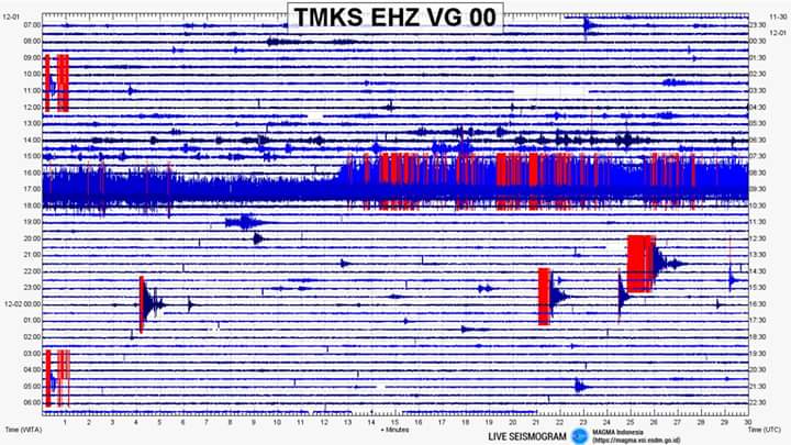
- The seismo for the last 24 is attached. It shows a continuous microtremor yesterday afternoon eventually ending after about 1.5 hours.
- PVMBG released an updated analysis last night at 9 pm, and it's packed with good info. I am uploading the translation into the files for this group (it's an easy read), but here are some of the key points I found interesting.
- Technically, eruptions have occurred on 21, 25, 27 and 29 November, each with a large ash plume. The biggest had a height of 4000 meters.
- Every night they are observing fire in the crater resulting from the glowing hot lava reflecting off the smoke. o Cold lahars (ash and water mixed) have affected houses, roads and rice fields.
- Deep and shallow earthquakes indicate that there is still magma movement at depth. The number has declined because the magma path to the surface has been more open. Although the number is low, it does not mean that volcanic activity has subsided.
- Continuous tremors indicate a high intensity of activity near the surface.
- Low frequency earthquakes are related to the movement of magma towards the surface.
- Tiltmeter measurements show inflation in the mountain before eruption and deflation after eruption.
- Laboratory tests on ash from the first eruption on the 21st showed some ash from new magma mixed with old ash from 1963. They call this a freatomagmatic eruption.
- SO2 (sulfur dioxide) measurements are being taken by drone. (SO2 indicates magma.) Before 21 Nov, there was little-no detection of SO2. SO2 measurements were high on 26-27 Nov and declined since then.
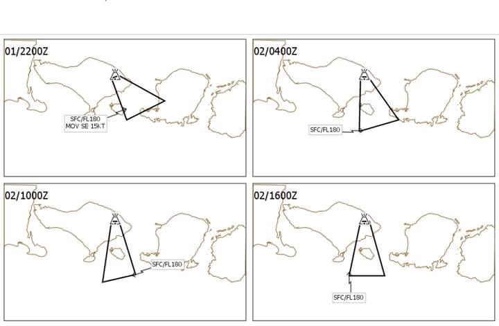
- Remote sensing satellite data indicates lava volume in the crater as increased with a volume of about 20 million cubic meters or one third of the total volume of the crater. o The Darwin VAAC predicts ash carried to the southeast, swing around to the south later today.
- DPS airport is currently open.
Text by Jackie Pomerov