15 December
Daily volcano update
Update of the graphic of the projected ash drift. Apparently the wind has picked up a bit at flight altitudes, and it's a bit stronger to the west.
The much-missed drone is back! The clouds finally cleared yesterday afternoon and the drone came back around 16:00 with its first video in a couple of weeks. It is attached below, and it provides a very good look at the state of the lava field in the bottom of the crater. Also see the post I shared earlier which compares photos of the crater taken 24 Nov and 14 december.
There is some discussion among technical experts that the lava flowing into the crater more recently has slowed substantially (remember they have a stack of other data, too, including high resolution satellite images), and this could mean that the underlying pressure from magma and gasses has declined.
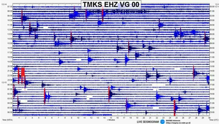
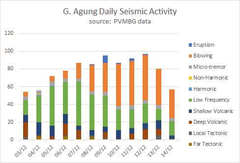
The seismogram and the daily numbers are attached, and things were relatively quiet yesterday – and supporting the discussion of weakening pressure inside the mountain. Blowing quakes from gas still dominate the numbers, but these are down by a third from 2-3 days earlier. The plumes reached 500-1500 meters (a bit weaker than the days before).
PVMBG noted that no plume was observed during the entire afternoon period (12:00-18:00). Glow from the crater was observed in the early hours this morning from the Batulompeh camera.
239 evacuation camps reported to BPBD yesterday that 71,863 evacuees were registered.
Volcanic ash drift today from FlightRadar24. The black outline is current (about 07:00 am), the green outline is +6 hours, the yellow is +12 hours, and the red is +18 hours. The wind is generally to the west, same as yesterday.
Gunung Agung General informations
Gunungapi Agung is one of the active volcanoes in Indonesia located in Karangasem, in the province of Bali. The peak is at the coordinated position of 115.431435 BT; 8.425043 LS with a height reaching 3142 meters above sea level. Historically, at least four eruptions occurred, the last eruption occurring between February 18, 1963 and January 27, 1964. Explosive Explosive Index
(VEINolcanic Explosivity Index) is of the order of 2 to 5 (last IEV 5). Monitoring of Agung volcanic activity is conducted through the Post Gunungapi Observation Post (Pos PGA) in Rendang Village, Rendang District.
Resume observations
Cloudy weather visually visible to the rain, the wind is weaker to the east and west. Temperatures around 22-29 C. The volcano is clearly visible until it is covered in 0-111 fog. The main smoke of the crater is white to gray with an average intensity about 1500 meters from the summit. Recorded then once the tectonic earthquake (Amax 14 mm, S-P 18 seconds, duration of 68 seconds).
3 times the volcanic earthquake (Amax5 - 25 mm, S-P 1 -3 seconds, duration 12 - 42 seconds).
4 times the shallow volcanic earthquake (Amax 2 - 21 mm, duration g - 25 seconds). 16 times Low Frequency (Amax3 - 15 mm, duration 25 - 110 sec). 32 times Blow (Amax 6 - 25 mm, duration 40 - 100 seconds). Tremor (Amax 1-2 mm (dominant 1 mm).
Conclusion
On the basis of the results of the visual and instrumental analysis of the observational data, it is concluded that Gunungapi Agung's activity level adapts to level IV (Awas). recommendations
The communities around G. Agung and climbers / visitors / tourists must not climb, climb or do any activity in the danger zone in the G. Agung crater and in all areas within a radius of 8 km from crater G. Agung. plus the sectoral extension to the northeast and south-east-south-southwest up to 10 km from the crater G. Agung. The estimated area hazards are dynamic and continually evaluated and can be modified at any time based on the latest / most recent G Supreme Observation data. Compiler report Anwar Sidiq, Histogram of earthquake by day
This report is generated automatically via MAGMA Indonesia (https://magma.vsi.esdm.go.id)

